[Research Report] China’s Marine Survey Ships as a Security Challenge for Japan and the Region
![[Research Report] China’s Marine Survey Ships as a Security Challenge for Japan and the Region](/eng/upload/eng/prc-maritime-2026-01.png)
Research Group on 'China and Maritime Interests / Order' 2026-# 1
"Research Reports" are compiled by participants in research groups set up at The Japan Institute of International Affairs, and are designed to disseminate, in a timely fashion, the content of presentations made at research group meetings or analyses of current affairs. "Research Reports" represent their authors' views.
I would like to express my gratitude to The Japan Institute of International Affairs for providing the research funds to purchase the AIS data used in this study. I would also like to thank ingeniSPACE for visualizing the data.
China is accelerating its expansion into the open seas. In June 2025, Japan’s attention was drawn to the first simultaneous deployment of two Chinese aircraft carriers in the northwestern Pacific near the Japanese islands of Okino-torishima and Minami-torishima, where they conducted operational exercises. China’s naval strategy had incorporated the new concept of “oceanic presence and polar expansion” as early as 2018 to complement traditional “near-sea defense and far-sea defense”.2 Before conducting naval operations, however, China must first collect various types of oceanographic data and gain an in-depth understanding of seabed topography, ocean currents, tidal patterns and other conditions. For this reason, China’s marine survey activities must have intensified even before the People’s Liberation Army (PLA) Navy began its operations in earnest.
For many years, the activities of Chinese marine survey ships did not receive as much attention as those of the PLA Navy and the China Coast Guard, or even the Chinese fishing boats serving as maritime militia that are now well-known for their role in gray-zone operations. However, increased use of open-source Automatic Identification System (ASI) data has made the global activities of Chinese marine survey ships better known. In particular, the 2025 circumnavigation of the Australian continent by the Chinese oceanographic research vessel Tan Suo Yi Hao (IMO: 8315451) sparked controversy in Australia. Since then, some observers have viewed Chinese oceanographic research activities as preparations for submarine warfare against the United States3.
Conversely, the domestic factors driving the expansion of China’s marine surveys remain unclear. Aiming to help address this research gap by examining Chinese policy documents and analyzing AIS data from a ship that sailed the waters around Japan in collaboration with ingeniSPACE, this paper argues that the Xi Jinping administration’s marine policy under the Military-Civil Fusion (MCF) strategy has turned China’s marine survey ships into instruments of gray-zone operations aimed at intimidating neighboring countries.
Challenges Posed by Marine Scientific Research (MSR)
The United Nations Convention on the Law of the Sea (UNCLOS) imposes certain restrictions but broadly recognizes all states’ freedom to conduct Marine Scientific Research (MSR) on the high seas, while imposing significant restrictions in coastal states’ EEZs and ocontinental shelves. With due consideration for the interests of coastal and other states, China and other countries may conduct such scientific research on the high seas. Even in deep seabed areas administered by the International Seabed Authority (ISA), states that are parties to UNCLOS may conduct MSR exclusively for peaceful purposes and for the benefit of humanity as long as they comply with relevant provisions. Additionally, UNCLOS stipulates that MSR may be conducted in waters under the jurisdiction of a foreign state such as territorial waters, Exclusive Economic Zones (EEZs), and continental shelves (including extended continental shelves) with the consent of the coastal state.
Coastal states are required to grant consent for other states to conduct MSR aimed at advancing scientific knowledge of the marine environment in their EEZs or continental shelves (Article 246, paragraph 3). In return, states that carry out MSR in the EEZ or on the continental shelf of a coastal state have a duty to comply with certain conditions, including providing the coastal state with all data, samples and research results derived from the MSR upon request and ensuring that the research results are made internationally available through appropriate national or international channels (Article 249). These procedural provisions, known as the consent regime, are based on the principle that MSR contributes to the advancement of knowledge about the marine environment.
The lack of a definition for MSR in the Convention has created ambiguity regarding the application of this article to certain types of marine data collection activities. Several categories of activities fall under the concept of marine data collection, including MSR, hydrographic surveys, military surveys, operational oceanography, exploration and the exploitation of natural resources4. The equipment used in MSR is identical to that used in military surveys and resource exploration that may infringe upon the sovereign rights of coastal states. For this reason, distinguishing these activities based on appearances alone is extremely difficult. On the other hand, one practical distinction often cited between military surveys and MSR lies in whether the survey/research results are published. Data collected from military surveys are confidential and not disclosed, while MSR findings are required to be published5. Furthermore, there is no consensus among nations regarding what constitutes peaceful use of the oceans as articulated by the Convention.
States have not yet reached an agreement under UNCLOS to regulate the military use of the oceans for the sake of the security of coastal states. Consequently, even though the scientific data collected by Chinese oceanographic research ships contribute to the growing activities of the PLA Navy in the Pacific and could alter the regional security balance, there is no general provision under international law to regulate their activities.
Chinese Military-Civil Fusion in the Seas
There is a significant difference between the concept of “scientific research to increase understanding of the marine environment” as envisioned by UNCLOS and China’s actual practices. While the Xi Jinping administration does not entirely disregard the common interest in increasing scientific knowledge of the marine environment for the benefit of all humanity, it does not prioritize this goal. The intent of the Xi administration’s maritime policy, as expressed by the term “经略海洋“, is to control the oceans for China’s unification and prosperity. In this context, the concept of MSR can be used to justify China’s maritime claims in disputed waters and the exploitation by China’s marine survey ships of other countries’ EEZs (ideally with consent) and areas beyond national jurisdiction, such as the deep sea and the high seas, for its own purposes.
The Xi Jinping administration has elevated China’s marine survey activities to new heights. In 2015, the Chinese government issued a policy document titled “Guiding Opinions on Strengthening Marine Surveys”. Seven civilian bureaucratic agencies, among them the State Oceanic Administration and the National Development and Reform Commission, signed the document, which called for the globalization of marine surveys and the regularization of marine surveys in certain prioritized areas as well as for expanded surveys of the “deep sea, open ocean, and polar regions6.” In 2016, Xi Jinping identified the technological challenges that must be overcome to make China a “world-class science and technology power” and called for accelerated efforts to acquire deep-sea exploration and development technologies7. In 2017, the Ministry of Science and Technology, the Ministry of Land and Resources, and the State Oceanic Administration notified local governments and other entities of the “13th Five-Year Plan for Scientific and Technological Innovation in the Marine Sector” (2016-2020) formulated in response to these initiatives. One of the plan’s key construction projects was the production of comprehensive marine survey ships capable of covering the polar regions, the open ocean, and the deep sea8.
China’s approach to the oceans, especially the deep sea, is based on Military-Civil Fusion (MCF) or Civil-Military Integration (CMI). MCF is a critical national strategy of the Chinese Communist Party (CCP) for military-technological innovation and development that seeks to transform the PLA into a “world-class military” by 2049.9 Take the “13th Five-Year Plan for Scientific and Technological Innovation in the Marine Sector,” for example. This policy document explains why China must enhance its scientific and technological capabilities in the deep sea. The primary objective is to secure control of the high seas and the deep sea. The next objectives are to counter threats from the deep sea, defend maritime territories, and improve the ability to respond to risks in sea lanes. Economic and environmental considerations are mentioned afterward10. Although the issuers and intended audience of the plan are civilian bureaucratic organizations, securing national security interests in the deep sea is prioritized above all else.
The aforementioned “Guiding Opinions on Strengthening Marine Surveys” states that the data collected through marine surveys will be integrated into a national digital platform to facilitate sharing and application. Although the document does not explicitly mention military use, the Chinese government’s deep-sea policy prioritizes national security interests over economic and environmental concerns. Therefore, the military utilization of data obtained through marine surveys is arguably inevitable.
In fact, the unpublished “National Military-Civil Fusion Strategic Plan” reportedly prioritizes MCF in the maritime domain above all else. As of 2019, discussions called for developing dual-use monitoring systems within China’s claimed “three million square kilometers of jurisdictional waters” to support economic activities at sea during peacetime and maritime operations during wartime11.
Marine Surveys as Gray Zone Operations
As mentioned in the previous section, the production of marine survey ships is one of the Chinese government’s priority projects. Construction of China’s largest oceanographic research vessel Zhong Shan Da Xue (MMSI413263240, 114.3 meters, 6,900 tons) was approved by the Ministry of Education in 2016 and is believed to have been carried out in accordance with the aforementioned “Guiding Opinions on Strengthening Marine Surveys”. The 708th Research Institute, affiliated with the China State Shipbuilding Corporation, began designing Zhong Shan Da Xue in July 2017, and construction of the vessel officially got under way in October 2019. After completing sea trials in June 2021, the vessel was deployed to serve a central role in ocean expeditions run by Sun Yat-sen University12.
According to Chinese media outlets, Sun Yat-sen University, located in Guandong Province, conducted China’s first marine survey of the Xisha Islands in the South China Sea in 1928. As China’s largest marine survey ship, Zhong Shan Da Xue is expected to once again demonstrate China’s resolve to other nations.
The AIS track left by Zhong Shan Da Xue in 2025 clearly embodied China’s maritime claims (Figure 1). From April to May 2025, Zhong Shan Da Xue left two distinctive crescent-shaped tracks in the Bashi Channel located between Taiwan and the Philippines, and sailed through the South China Sea from May to June of the same year, tracing the outer edge of China’s Nine-Dash Line claim (Figure 1).
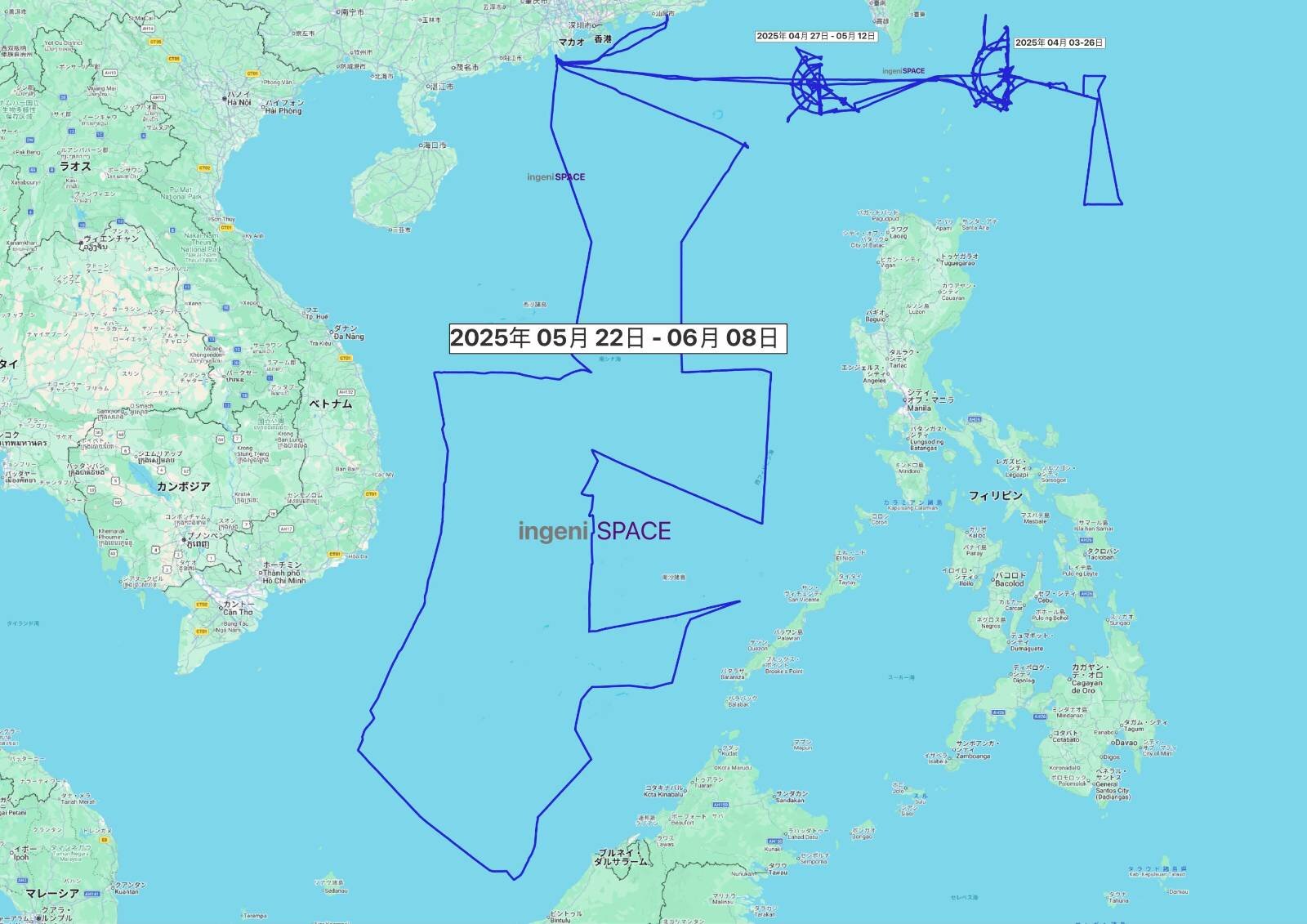
(Figure1) AIS data showing the voyage of the Chinese marine survey ship Zhong Shan Da Xue (MMSI 413263240) from Taiwan to the South China Sea from April to June 2025
The first crescent-shaped track was observed off the coast of Kaohsiung in southern Taiwan, within Taiwan’s claimed EEZ. The second was observed on the Pacific side of eastern Taiwan, within the Philippines’ EEZ (Figure 2). Philippine Coast Guard spokesperson Jay Tarriela commented only on Zhong Shan Da Xue’s movements along the crescent-shaped track observed from April 3 to 26, pointing out that Zhong Shan Da Xue had spent a considerable amount of time within the Philippine EEZ 145 kilometers (90 miles) northeast of Itbayat Island, conducting marine surveys without Philippine consent. To the best of this author’s knowledge, the Coast Guard Administration of Taiwan’s Ocean Affairs Council has not officially remarked on Zhong Shan Da Xue‘s movements.
What was the Chinese marine survey ship doing when it left an unusual crescent-shaped track pattern in the Bashi Channel? Sun Yat-sen University has not issued a statement about the activities in the Bashi Channel, despite having done so following Zhong Shan Da Xue’s 2025 voyages in the South China Sea. The US think tank Institute for the Study of War (ISW) has suggested two possibilities: (1) China was conducting seabed surveys to facilitate submarine operations in the event of a blockade of the waters around Taiwan and (2) China was using its marine survey ship to install devices on the Batanes Islands in the northern Philippines that could attack surface ships. This latter action could be seen as a countermeasure against the US transfer of anti-ship missile systems to the Batanes Islands, according to the ISW13.
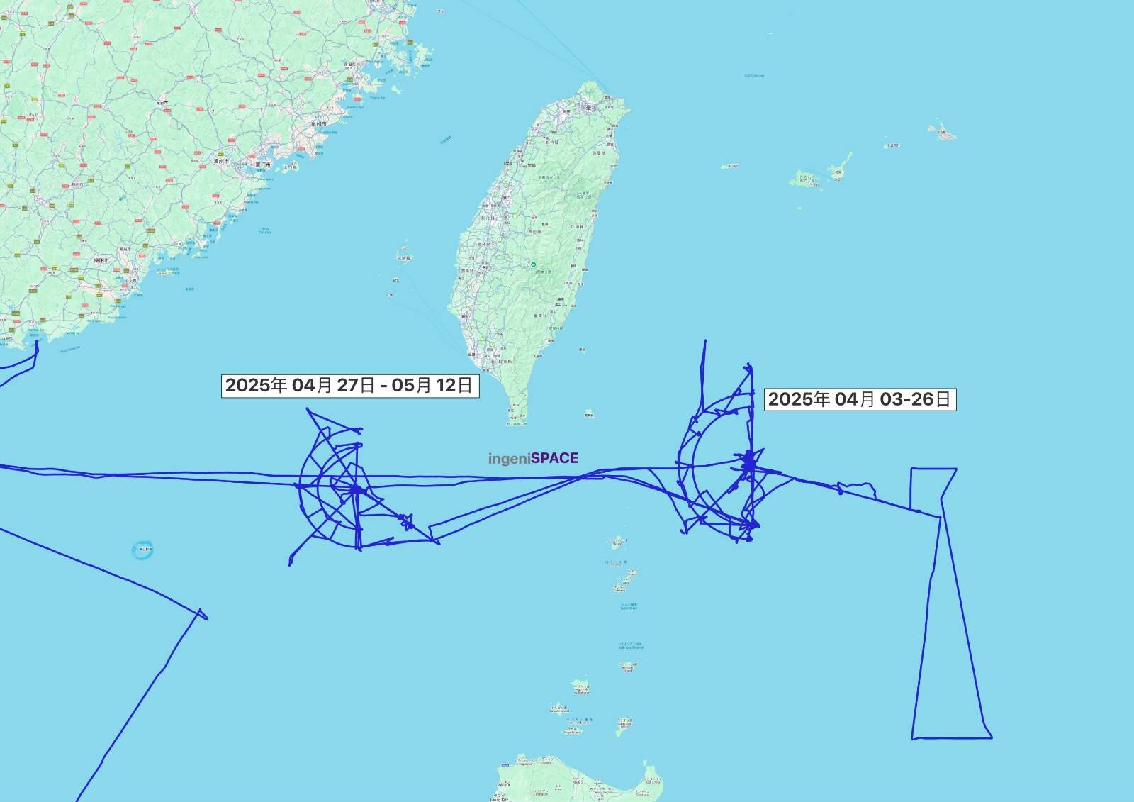
(Figure 2) Movements of the Chinese marine survey ship Zhong Shan Da Xue (MMSI 413263240) in the Bashi Channel, as recorded in AIS data (April–May 2025)
According to AIS data, the research vessel Zhong Shan Da Xue sailed through the South China Sea from May to June 2025. However, Sun Yat-sen University declared that the vessel was active in the South China Sea in August 2025, which contradicts the AIS data. The announcement stated that Sun Yat-sen University had conducted sea-trials of Haiqin, a remotely operated vehicle (ROV) capable of operating at depths of up to 6,000 meters, and that Zhong Shan Da Xue had deployed the Haidou-1 autonomous underwater vehicle (AUV) at the same time. This marked the first scientific survey conducted by coordinating two different unmanned vehicles via a single support ship14.
China may argue that these activities fall under MSR as defined by UNCLOS. However, it is highly plausible that the crescent-shaped survey pattern left by Zhong Shan Da Xue in the Bashi Channel was most likely part of a strategic operation to potentially blockade Taiwan. At the very least, it can be argued that Zhong Shan Da Xue collected data enabling China to use the Bashi Channel during both peacetime and wartime. Furthermore, by conducting marine surveys along the “Nine-Dash Line” in the South China Sea, China is disregarding the 2016 South China Sea arbitration ruling. These surveys deviate significantly from UNCLOS’s principle of MSR aimed at gaining a thorough understanding of the marine scientific environment for the benefit of all humanity. Chinese marine survey vessels must be viewed as key actors in China’s gray-zone operations, alongside China Coast Guard ships and fishing boats.
From October to November 2025, Zhong Shan Da Xue passed through the Osumi Strait, located between Japan’s Osumi Peninsula and Tanegashima Island, and conducted marine surveys in international waters in the northwestern Pacific beyond the Second Island Chain (Figure 3). Japan has protested China’s marine surveys conducted without its consent through the Japan Coast Guard and diplomatic channels, and it is imperative that Japan ascertain the objectives of China’s marine survey ships just outside its EEZ and devise countermeasures as necessary.
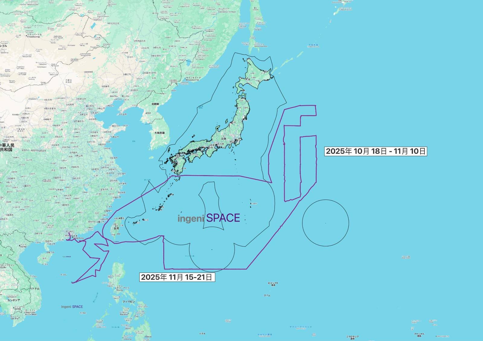
(Figure 3) Movements of the Chinese marine survey ship Zhong Shan Da Xue near Japan’s EEZ as recorded by AIS data from October to November 2025.
(Finalized on March 31, 2026)
(This is an English translation of a Japanese paper originally published on May 14, 2026)
- Associate Professor in the Department of Political Science at Doshisha University, Kyoto, Japan. She also works as a member of “Compass Voice”, the Japan Coast Guard’s network of external experts, having been appointed by the Commandant of the Japan Coast Guard in 2025, and serves as an adjunct research fellow at the Japan Coast Guard Academy’s Center for Maritime Safety and Security Studies.
- Ryan D. Martinson, “The Role of the Arctic in Chinese Naval Strategy,” China Brief, Volume 19 Issue 22, (20 December 2019), https://jamestown.org/the-role-of-the-arctic-in-chinese-naval-strategy/
- Euan Graham and Ray Powell, “Seabed sensors and mapping: what China’s survey ship could be up to,” The Strategist, Australian Strategic Policy Institute (ASPI), April 9, 2025. https://www.aspistrategist.org.au/seabed-sensors-and-mapping-what-chinas-survey-ship-could-be-up-to/. Regarding the idea that Chinese marine survey ships are preparing for submarine warfare, see Jennifer Parker, “China’s “spy ship” that wasn’t off the coast of Australia,” The Interpreter, Lowy Institute, April 17, 2025. https://www.lowyinstitute.org/the-interpreter/china-s-spy-ship-wasn-t-coast-australia. For a report covering the activities of Chinese marine research vessels in the Pacific Ocean, Indian Ocean, Arabian Sea, and waters around Japan, see Peter McKenzie, “China is mapping the ocean floor as it prepares for submarine warfare with the US,” March 24, 2026.
https://www.reuters.com/investigations/china-is-mapping-ocean-floor-it-prepares-submarine-warfare-with-us-2026-03-24/ - Sookyeon Huh and Kentaro Nishimoto, “Article 246: Marine Scientific Research in the Exclusive Economic Zone and on the Continental Shelf” in Alexander Proelss (ed), The United Nations Conventions of Law of the Sea: A Commentary (Beck, Munchen, 2017), pp.1655-1657.
- Huh/Nishimoto, p 1656.
- Ministry of Natural Resources, “Notification on the Issuance of “Guiding Opinions on Strengthening Marine Survey Work” by the State Oceanic Administration, National Development and Reform Committee, Ministry of Education, Ministry of Science and Technology, Ministry of Finance, Chinese Academy of Sciences, and National Natural Science Foundation,” March 30, 2015,
https://gc.mnr.gov.cn/201806/t20180614_1796464.html - Ministry of Science and Technology, “Xi Jinping: Striving to build a world-class scientific and technological superpower,” May 31, 2016,
https://www.most.gov.cn/ztzl/qgkjcxdhzkyzn/btxw/201705/t20170526_133113.html - Ministry of Science and Technology, “Notification on the Issuance of “The 13th Five-Year Plan for Scientific and Technological Innovation in the Marine Sector” by the Ministry of Science and Technology, Ministry of Land and Resources, and State Oceanic Administration, May 8, 2017, p 21.
https://www.most.gov.cn/xxgk/xinxifenlei/fdzdgknr/fgzc/gfxwj/gfxwj2017/201705/t20170517_132854.html - Elsa B. Kania, “In Military-Civil Fusion, China is Learning Lessons from the United States and Starting to Innovate,” The Strategy Bridge, August 27, 2019, https://thestrategybridge.org/the-bridge/2019/8/27/in-military-civil-fusion-china-is-learning-lessons-from-the-united-states-and-starting-to-innovate; Richard A. Bitzinger, “China’s Shift from Civil-Military Integration to Military-Civil Fusion,” Asia Policy, Vol 16, number 1 (January 2021), pp.5-24; Tai Min Chung, “The Promise and Peril of Military-Civil Fusion,” Innovate to Dominate: The Rise of the Chinese Techno-Security State, (Ithaca, NY: Cornell University Press, 2022), pp.83-141.
- “The 13th Five-Year Plan for Scientific and Technological Innovation in the Marine Sector,“ pp.6-8.
- 张子利,“军民一体化智慧海洋建设及海洋信息安全问题研究,”网信军民融合 (Civil-Military Integration on Cyberspace),2019, pp.23-26.
- 中山大学海洋科学考察中心,”船舶概况,“ 2021, https://coe.sysu.edu.cn/ship/size
- Institute for the Study of War, “The China-Taiwan Weekly Update,” May 8, 2025, https://understandingwar.org/wp-content/uploads/2025/06/China-Taiwan20Weekly20Update2C20May2092C2020252028PDF29_0.pdf
- Sun Yat-Sen University, “China’s new deep-sea explorer Haiqin completes mission in South China Sea,” August 25, 2025. https://www.sysu.edu.cn/sysuen/info/1023/57251.htm; https://english.news.cn/20250824/2aa27942c7404e548c470c2afafcbfc4/c.html